Shihlungtong Fm
Type Locality and Naming
The type section is the Shilongdong section, called as Stone Woekshop section by Wang (1938), lying on the south bank of Yangtze River, about 16 km northwest of the seat of Yichang City (111°09’49” E, 30°46’31” N). The section lacks lower interval of the formation. Based on the was remeasured type section and an additional section by Zhang (1978). Chen and Jin (1996) proposed a composite section as representative section of the formation. The Shihlungtong Formation was named by Wang (1938). The name is derived from Shihlungtong (spelled Shilongdong in Hanyu Pinyin) Cave in East Yangtze Gorges, Yichang City, western Hubei Province. Wang (1938) originally called the formation Shihlungtong Limestone. Subsequently it was renamed Shihlungtong Formation by Lu (1962).
Synonym: (石龙洞组)
Lithology and Thickness
The Shihlungtong Formation is a carbonate sequence. Lower part consists mainly of dark grey, medium-bedded dolomite and calcareous dolomite (36.92 m); Upper part is greyish brown and greyish white, medium- to thick-bedded, “gravel”-containing dolomite with minor interbeds of chert or containing chert-lumps in uppermost part (62.44 m). Regionally, the formation is stable in lithology and varies mildly in thickness between 46 and 134 m. In the type section, the formation is 99.25 m thick.
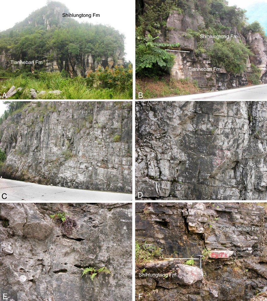
[Figure: Contact relationships and lithology of the Shihlungtong Fm on the Yichang-Liantuo highway side, near Tianheban Village in the Yangtze Gorge area, Yiling District, Yichang, western Hubei Province, South China. A, B, the contact relationship between the underlying Tianheban Fm and the Shihlungtong Fm; C, outcrop of the Shihlungtong Fm; D, E, close-up views of the dolomite of Shihlungtong Fm; F, the contact relationship between the Shihlungtong Fm and the overlying Chinchiamiao Fm. Diameter of the coin on E = 24 mm.]
Relationships and Distribution
Lower contact
The Shihlungtong Fm is in conformable contact with the underlying either Tianheban Fm or Shipai Fm. The lower boundary of the formation is defined by the lithologic change from the thin-bedded argillaceous striped limestone of the underlying Tianheban Fm to thick-bedded in the Yangtze Gorge area, western Hubei, or from the underlying dolomitic shale or siltstone of Shipai Fm in the Dahongshan Mountain area in northern Hubei and Chengkou area in northwestern Chongqing.
Upper contact
The Shihlungtong Fm is in conformable contact with the overlying Chinchiamiao Fm, or Kaotai Fm or Yangliugang Fm. The upper boundary is also defined by the lithologic change with the appearance of thin-bedded argillaceous dolomite at the base of Chinchiamiao Fm in the East Yangtze Gorge, western Hubei Province; the appearance of oolitic dolomite at the base of Kaotai Fm in the Enshi area, southwestern Hubei Province; or the appearance of thin-bedded argillaceous limestone at the base of Yangliugang Fm in the Puqi-Tongshan area in southeastern Hubei Province.
Regional extent
The Shihlungtong Formation is exposed in the Yangtze Area of South China Region, distributed mainly in western, southwestern, and southeastern Hubei Province (Yichang, Xiangyan, and Xianning cities and Enshi Tujia and Miao Autonomous Prefecture) and northwestern corner of Hunan Province (Longshan County of Xiangxi Tujia and Miao Autonomous Prefecture).
GeoJSON
Fossils
The Shihlungtong Formation is poorly fossiliferous with no fossils found from the type section. So far as known, a few of trilobites are reported from two localities in southeastern Hubei Province, i.e., the formation at Zhenzhukou of Tongshan County yields, Redlichia sp. and Yuehsienszella sp., and the formation at Zhujiayu of Nanzhang County yields R. guizhouensis, R, murakamii, and R. sp.
Age
Depositional setting
The formation represents low-energy to high-energy sedimentary environment with rather highly magnesian shallow water
Additional Information
